European Waterways
This site is all about inland navigation on canals and navigable rivers in Europe. Waterways are divided either into inland waterways or seaways. This division on the overall use of the waterways. An inland waterways can still be deemed as seaways if it is mostly used by sea ships. This is clearly the case with the Kiel Canal, because the canal is an inland waterways but dedicated to maritime use.
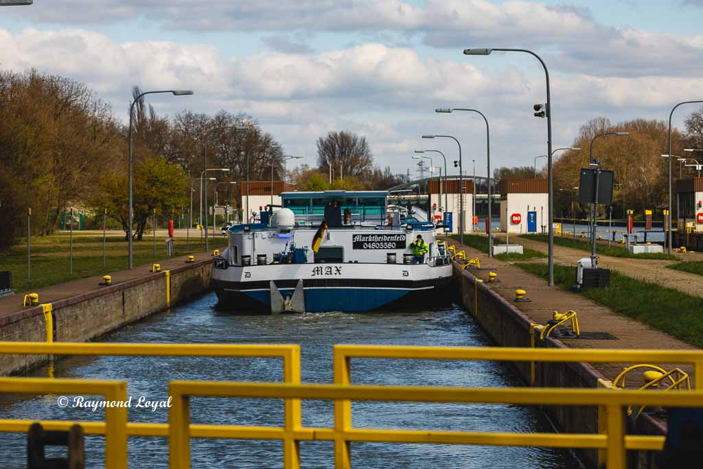
Inland waterways are all navigable rivers and canals also including inland lakes connected to inland waterways. In Germany 64 inland waterways are administered by the Federal Republic of Germany and are therefore called federal waterways. Both navigable rivers and canals build a coherent network of inland waterways which is indespensable for the transport mass goods to supply the economy. Barges are the only means to cost-effectively und environmentally-friendly transport high transport volumina. Because of the high transportation volumes that can be moved by one barge, inland navigation is far ahead even of the railway.
Apart from providing the waterways to inland navigaton, the waterways net also provides other vital functions such as the controlled influx and drain of floods. On top of that, canals supply the industry with raw water or process water and rivers secure the supply of drinkable water.
Then waterways appear to have high importance to fishing and angling and to sports and recreational boating as these private ships and boats are allowed to drive on federal waterways.
Canals and rivers of the German waterways net have the vital function of connecting the European waterways net to a huge waterways network, thereby linking with France, Switzerland, Poland, Czech Republic, Slowakia, Austria, Romania, Hungary, Serbia and Bulgaria. It also allows Dutch and Beligum barges to reach the Black Sea by using the river Danube.
This site is dedicated inland navigation and publishes editorials on aspects of barge transports and also on canals in Germany and Europe.
The German Inland Waterways Network
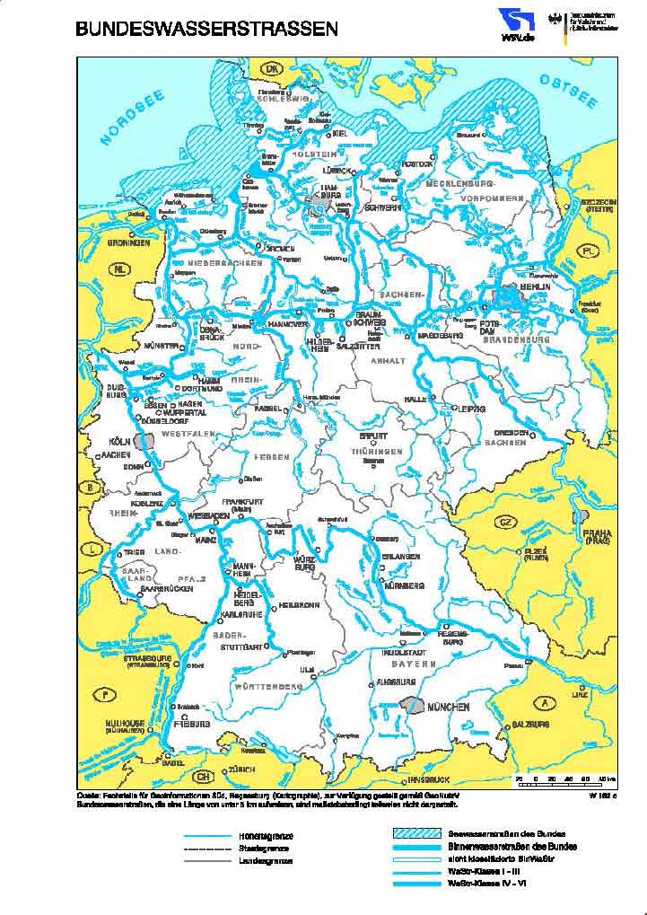
The German waterways network consists of navigable rivers, lakes and canals and is divided into seven sections. Waterway law differentiates between inland waterways and seaways. On this side we focus on inland waterways. According to German law all inland waterways are administered by federal administration.
German federal waterways covers a network of about 7.350 kilometres of inland waterways of which only 25 percent are canals. The German waterways net connects waterways in the west and the east of Europe, with the German network being the largest by far, followed by the Dutch ranking second.
Only visualise the vastness of the waterways net, it should be mentioned that the German motorway network covers motorways and motor roads with a total length of 13.141 kilometres, whereas the German network of federal roads covers a length of 37.879 kilometres, making the German road network the most dense in the whole of Europe
The seven parts of the German waterways network are North, Northwest, East, West, Centre, Southwest and South. Below the network parts are explained in detail:
North:
- Kiel Canal (NOK) - length 98.26 k - two lock systems
- Eider
- Stöhr - from rivel level Rensing down to Stöhr's confluence with the river Elbe
- Krückau - from Elmshorn City down to the river Elbe
- River Elbe
- Oste - from the Oste barrage (kilometre 69.36) down to the Oste's confluence with the river Elbe
- Untertrave - navigable from kilometre 5.57 to kilometre 26.94
- Peene Canal
Northwest:
- Unterems, Außenems, Ems-Seitenkanal (Ems Lateral Canal) - navigable from kilometre 0.00 to kilometre 92.00
- Ems-Jade Canal (EJK)
- Untere Hunte
- Lesum - navigable from the confluence of the rivers Hamme and Wümme (kilometre 0.00) until the confluence with the river Elbe
- Wümme
- River Weser
West:
- Küsten Canal (KüK) - length 69.69 k - 1 lock systems
- Dortmund-Ems Canal (DEK) - length 225.82 k - 16 locks - begins at Dortmund City Harbour and ends at Papenburg by merging into river Ems
- Datteln-Hamm-Canal (DHK) - length 47.145 kilometres - branches off Dortmund-Ems Canal at kilometre 19,51 and ending at RWE Harbour Schehausen at kilometre 47.20 - 2 locks
- Wesel-Datteln Canal (WDK) - length 60 kilometres - 6 locks - ending at Datteln by merging into Dortmund Ems Canal at canal cross Datteln
- Rhein-Herne Canal (RHK) - length 45.6 kilometres - branches off the river Rhine at Rhine kilometre 780.40 (Ruhrort) and ending at Herne by merging with Dortmund-Ems Canal
- River Rhine
- River Ruhr - navigable from kilometre 0.00 to kilometre 41.60 where the Ruhr flows into the Rhine at Rhine kilometre 780.14 (Duisburg Ruhrort), 6 locks
East:
- Elbe-Lübeck Canal (ELK) - length 61.55 kilometres
- Ilmenau
- Stör Waterways (Stör Wasserstrasse)
- Müritz-Elde Waterways (MEW)
- Müritz-Havel Waterways (MHW) - length 32 k
- Obere-Havel Waterways (OHW) - length 97.4 k
- Havel-Oder Waterways (HOW) - length 135 k
- Untere-Havel Waterways (UHW) - length 148.43 k
- Havel Canal (HvK)
- Elbe-Havel Canal (EHK) - length 55 k
- Teltow Canal (TeK) - length 38.29 k
- Landwehr Canal (LWK) - length 11 k
- Spree-Oder Waterways (SOW) - length 129 k
- Oranienburg Canal (OrK) - length 8.98 k
- River Oder - navigable from kilometre 542.40 to kilometre 741.60
- River Saale navigable length of 89.20 kilometres
- River Elbe
Central:
- Midland Canal (MLK) - length 325.3 k - begins at Dortmund-Ems Canal near the town of Bergeshövede and ends by merging into Elbe-Havel Canal at Hohenwarthe - 3 locks
- Elbe Lateral Canal (ESK) - length 115 kilometres - 2 locks
- Aller - navigable length of 117.60 kilometres
- River Weser
- River Leine
- River Werra
- Untere Fulda (river) - navigable between kilometre 76.78 to kilometre 108.78
Southwest:
- River Rhine
- River Mosel - navigable length 392.45 kilometres and flowing into river Rhine at Rhine kilometre 592.30 - 10 locks
- River Saar - navigable length 94.06 from the estuary into river Mosel down to the German border
- River Neckar - navigable length 203.01 kilometres - Neckar estuary into river Rhine at Rhine kilometre 428.16
- River Lahn - navigable length from kilometre 137.30 to kilometre 70.00 - Lahn estuary into river Rhine at Rhine kilometre 585.72
South:
- River Main - navigable length from kilometre 0.00 to kilometre 387.69 - Main estuary into river Rhein at Rhine kilometre 496.63
- Main-Donau Canal - Main-Danube Canal (MDK) - length 170,71 k 16 locks - begins by branching off river Main near Bamburg - ends at Kelheim by merging with river Danube
- River Danube - navigable from kilometre 2414.84 to kilometre 0.00 (Bulgaria) - Begin as federal waterways at kilometre 2414.72 down to kilometre 2224.70 (Austrian border) navigable length in Germany: 190.14 kilometres.
The river Rhine is the longest navigable river in Germany and, over its navigable length of 884 k, crosses six European countries, thereby connecting Basel in Switzerland with the ports of Rotterdam and Antwerp. The overall length of the river Rhine is 1233 kilometres. Only from Rheinfelden in Switzerland the river Rine is navigable at river kilometre149. In Basel the Rhine is already a wide river. On a worldwide scale the river Rhine is amongst the most busy waterways.
The river level of the river Rhine is measured at 18 stations along the river, with the most important measuring stations at Kaub, Koblenz, Colgone, Ruhrort and Emmerich.
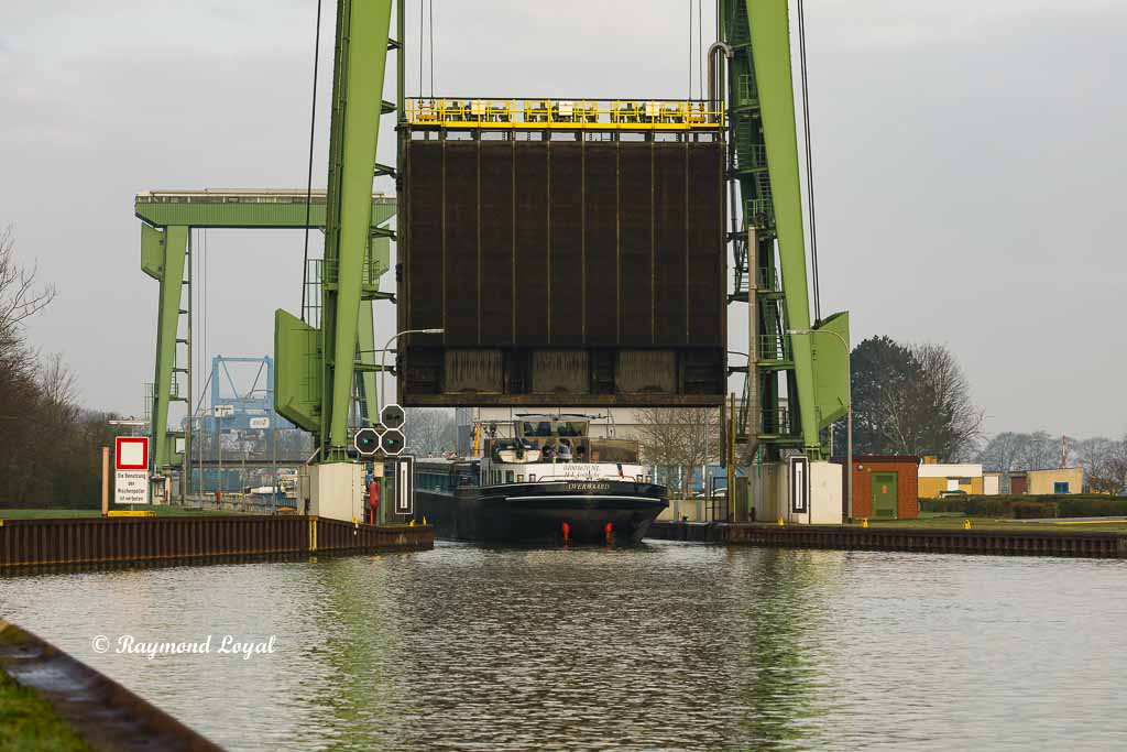
Wesel-Datteln Canal (WDK)
The reason for building the Wesel-Datteln Canal was that there was too much traffic on parallel running the Rhein-Herne Canal. In order to ensure that industry in the Ruhr area could be supplied with goods at any time, planning for a new canal begun and canal building started in earnest in 1915, actually during World-War I, leading to a rather late completion in 1930.
The Wesel-Datteln Canal branches off the river Rhine at Rhine kilometre 813.24, near Wesel and close to Harbour Emmelsum; the total length of the canal is 60 k. Over its course the canal runs through the Lippe valley and more or less parallel and south of the river Lippe. At kilometre 60.23 the Wesel-Datteln Canal merges with the Dortmund-Ems Canal.
Read more Wesel-Datteln Canal (WDK).

Dortmund-Ems Canal (DEK)
Dortmund-Ems Canal was built in the 19th century between 1892 and 1899, the official opening of the canal was on August 11th 1899, in the presence of German emperor Wilhelm II. The canal starts at Dortmund City Harbour and ends at the town of Papenburg by merging with the river Ems. Over a length of 225.82 kilometres the canal has 10 lock systems.
At the Canal Junction Datteln / Waterways Junction the canal meets up with Wesel-Datten Canal, coming from the west and Rhein-Herne Canal coming up from the south.
Read more at Dortmund-Ems Canal (DEK).

Rhein-Herne Canal (RHK)
The construction of the Rhein-Herne Canal still fals in the time of the Empire. In order continuously supply steel works and metallurgical plants in the Ruhr area a canal was needed to run through the southern part of the Ruhr area. A side effect was to connect Dortmund-Ems Canal with the river Rhine. Inn its course the canal runs through the middle of the hard coal mining fields.
Read more at Rhein-Herne Canal (RHK).